TreeSense: 3D vision and machine learning for automated tree measurement
In tree nurseries, trunk circumference determines value, yet tree measurement is still largely manual and therefore time-consuming and prone to inconsistency. To address this challenge, AIgro developed TreeSense, an automated sensing system for high-precision measurement and mapping of individual trees in outdoor environments. Nobleo contributed its expertise in image processing, machine learning and 3D vision, helping the system detect, analyse and measure individual trees based on field data.
A partnership built on complementary strengths
AIgro specialises in developing autonomous vehicle carriers for agricultural application. When they wanted to add intelligent tree-sensing capability to their vehicles, they turned to Nobleo because of their proven track record in combining 3D camera systems with machine learning across multiple industrial domains. “The initial brief was precise,” says Rik Wetzels, System Engineer at Nobleo. “We were asked to build a camera system capable of determining the diameter of a tree trunk to within +/- 1cm accuracy while simultaneously recording its exact position in the field.”
From manual estimation to automated precision
For tree nurseries, trunk circumference is a commercial category. The value of a tree is determined based on its size and customers order batches of trees by size range. “Today, the size is determined by hand,” Rik explains. “Workers walk the rows with a tape measure, measuring each trunk at approximately one meter above the ground. Of course, this method is prone to inaccuracies and very time consuming at that.”
In addition, inventory is managed at group level rather than per individual tree and based on rough estimates. The margin for error is wide and disputes with customers do happen when trees are delivered that fall outside the ordered category. The solution Nobleo was asked to develop directly addresses both challenges by enabling accurate, individual measurement and precise positioning of each tree.
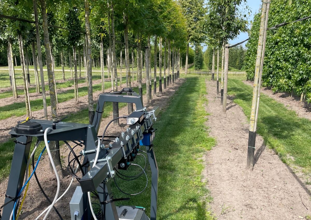
Sensor strategy for outdoor 3D sensing
The development process followed a clear, phased approach, starting with a thorough analysis of available sensors. Rik: “The requirements where demanding: sub-millimetre depth resolution, reliable performance at distances between 40 and 160 cm, and the ability to capture data while moving through the field at approximately 2.5 km/h. In addition, the system had to be able to operate in outdoor conditions and synchronise accurately with GPS data.”
Based on these criteria Nobleo selected a high-end 3D camera capable of generating detailed point clouds: dense, accurate representations of three-dimensional surfaces. “Because we had already used such a sensor in another project, we could build on existing knowledge and mainly focus on the actual analytical challenge.”

3D mapping of individual trees
With AIgro providing access to nursery sites and handling all vehicle navigation, the Nobleo team together with the AIgro team started testing the sensor by scanning a number of rows comprising a total of more than 350 trees of seven different species. “As the vehicle moved through each row, the sensor captured partial views of each tree from multiple angles,” Rik explains. “The robot itself captured detailed information about it’s exact position and orientation in the world. We then used an algorithm we especially built for this purpose to combine those separate views, together with the position information of those views, into a clear, comprehensive overview map.”
A key challenge were the bamboo stakes nurseries use to hold the trees upright. Initially, the system had difficulty differentiating between the trunk and the stake. Rik: “We therefore measured the circumference of the stakes as well and as those are consistently uniform, we could easily filter them out before applying geometric measurements to the tree trunk.”

Reliable measurement results through 3D analysis
The field tests showed that the approach works in practice. By scanning rows at operational speed and combining multiple observations per tree, the system was able to determine trunk diameters with an accuracy in the order of one centimetre. When comparing those results to the outcome of a measurement done by hand, the results of the latter were a lot less accurate and consistent. “If you measure the same tree multiple times, you want to see roughly the same outcome every time,” Rik says. “That consistency is what makes the data usable for real decision-making.” By combining measurements with precise position data from the vehicle, the system can generate detailed maps of entire parcels, showing exactly where each tree is located and what its measurements are.

Unlocking new possibilities for agricultural automation
While TreeSense focuses on measuring tree trunks, the underlying technology is widely applicable across the agricultural domain. By combining machine learning with 3D sensing, generic objects can be detected in complex outdoor environments and analysed with high geometric precision. This opens the door to a wide range of use cases, from monitoring crop growth and analysing plant health to detailed inventory management to better support the customer’s needs. “Once you can reliably detect objects on images and measure them in 3D, you can start building much richer insights about what’s happening in the field,” Rik explains. “For growers and nurseries worldwide, this means new opportunities to improve efficiency, reduce manual labour and make better-informed decisions based on accurate, consistent data.”
Curious how this technology could be applied in your domain? Get in touch with Nobleo to explore the possibilities.


This project has been made possible in part by a contribution from the Eindhoven Metropolitan Area Fund NL